HIKING TRAILS
Discover Denmark’s largest area of marshland, Tøndermarsken.
The 54-kilometre Marsh Trail and eight shorter hiking trails take you to see every corner of Tøndermarsken.
THE MARSH TRAIL
")

Distance: 54 km
The fifty-four kilometres of hiking trail bring you closer to this very special landscape. At first glance, the natural environment here seems bleak and untamed but it was designed meticulously – formed by the lives of local people who worked with and against the water.
When you walk the Marsh Trail, you feel the wind on your face and observe a flat landscape with dykes and birds as far as the eye can see.
The trail takes you to everything from dykes and pumping stations to extensive marshlands, canals and lakes with outstanding natural environments and bird life.
On the marsh’s perimeter, you walk through a number of unique small towns. Tønder, Møgeltønder and Højer are located on The Geest. Rudbøl and Nørremølle are the only towns in Denmark built on dykes.
Leading Quality Trail
Marskstien is certified as a quality hiking route: Leading Quality Trail – Best of Europe. The recognition comes from the European Ramblers Association, the European hiking organization. Certification requires meeting a wide range of criteria, including signage, surfacing, facilities, and experiences.
SHORTER CIRCULAR ROUTES

Distance: 2.7 – 12 km
There are eight shorter hiking trails associated with the Marsh Trail.
All the shorter hiking trails are circular routes, which start and finish at the same place. It is a good idea to start your hike in one of three towns – Tønder, Højer or Rudbøl – because each of the shorter hiking trails goes through one of these towns.
Each of the shorter hiking trails is colour-coded: green, blue, red or black, according to its length.
The green trails are shortest, black longest.
The shorter hiking trails are described below.

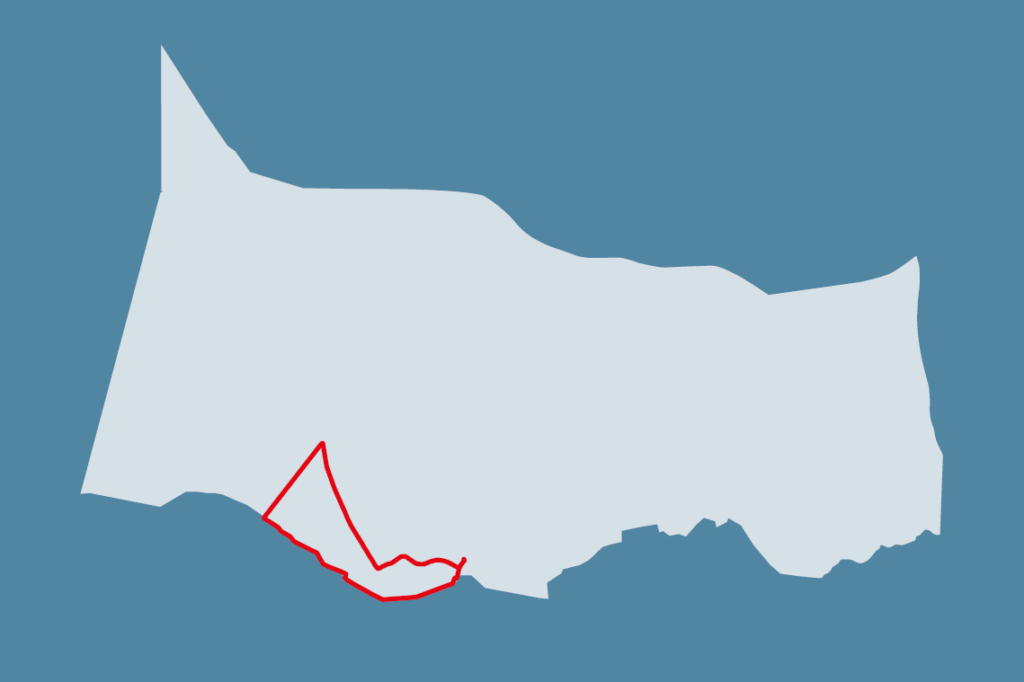
Højer, Højer Sluice: (GREEN HIKING TRAIL)
Start at: Højer Mølle Windmill
Distance: 4.2 km
Sightseeing: Højer, Kiers Gaard cultural centre, Højer Pumping Station, Højer Harbour, marsh boats and tilters (fishing huts).
Learn about and discover Tøndermarsken on a trail that is only 4 kilometres long. This trail brings you to many of Tøndermarsken’s unique features. You discover the dykes, sluices, irrigation and drainage canals, Højer Harbour and the marsh farms.
The trail starts at Højer Mølle Windmill and leads you past Højer Pumping Station to Højer Harbour. The trail continues to Højer Sluice and then back to Højer, passing several sights, e.g. Kiers Gaard cultural centre, on the way.
NB: The terrain on the dykes is uneven.

Højer, Emmerlev Klev, Vidå Sluice: (RED HIKING TRAIL)
Start at: Højer Mølle Windmill
Distance: 9.4 km
Sightseeing: The Wadden Sea, UNESCO World Heritage Site, Det Fremskudte Dige (the forward dyke), Vidå Sluice, Margrethe Kog (protected bird habitat), the old sea dyke (1861), Højer Sluice, Højer, Kiers Gaard cultural centre.
Along the Wadden Sea. On this tour, you walk on old and new sea dykes. Discover the Geest and the steep slope at Emmerlev Klev and beautiful views across the Wadden Sea.
The round trip starts at Højer Mølle Windmill and takes you to Emmerlev Klev and the new Vidå Sluice and then back to Højer, passing Højer Sluice and following the old sea dyke built in 1861.
This trail is accessible to everyone, including wheelchair users.

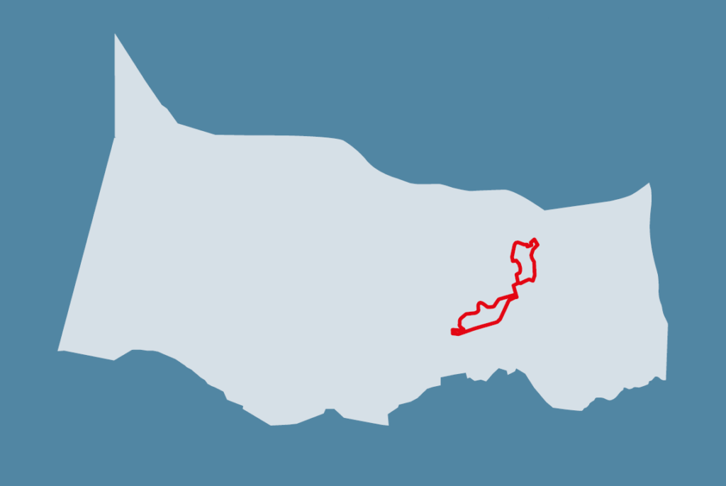
Højer, Klæggravene, Margrethe Kog: (BLACK HIKING TRAIL)
Start at: Højer Mølle Windmill
Distance: 12 km
Sightseeing: The central section of Tøndermarsken (Margrethe Kog and Ny Frederiks Kog), The Wadden Sea National Park, birds, canals, old sea dyke (built in 1861, listed).
Geese, waders and white-tailed eagles. This round trip takes you to the old sea dyke (built in 1861) with Margrethe Kog on one side and Frederiks Kog on the other. Margrethe Kog (or polder) is one of Europe’s most important bird habitats. You can spot barnacle geese, white-tailed eagles, ducks and many species of wading birds here.
The trail starts at Højer Mølle Windmill and leads you past Højer Sluice. You walk along the old sea dyke and back to Højer via the river dyke along Vidå Stream. At Højer, you pass several sights, including Kiers Gaard cultural centre.
NB: The terrain on the dykes is uneven.


Rudbøl, Vidå Stream: (BLUE HIKING TRAIL)
Start at: Rudbøl
Distance: 4.2 km
Sightseeing: Rudbøl, boundary stones, Gammel Frederiks Kog, Vidå Stream.
Rudbøl – a border town in dyke country. Nørremølle and Rudbøl are the only Danish settlements built on dykes. Rudbøl is located on the oldest of Tøndermarsken’s dykes, built in 1556. There are many dwelling mounds on the path to Rudbøl Lake and the Danish-German border.
The tour starts in Rudbøl and passes along the Danish-German border. You pass Gammel Frederikskog and walk on the river dyke (built in 1930) and along Vidå Stream back to Rudbøl.
NB: The terrain on the dykes is uneven.
Rudbøl Border, Gammel Frederikskog: (RED HIKING TRAIL)
Start at: Rudbøl
Distance: 11.4 km
Sightseeing: Boundary stones, Nørremølle, Border Guard Trail along the border.
Walk along the Danish-German border on the historical Border Guard Trail. On this trip, you experience Gammel Frederikskog with its field drainage furrows – and sheep, sheep and more sheep! You pass Nørremølle and Rudbøl, the only Danish settlements built on dykes. In Rudbøl, the boundary stones that mark the border between Denmark and Germany run down the middle of the main road and out into Rudbøl Lake. Rudbøl is the westernmost border town on the Danish-German border.
The trail starts in Rudbøl: You walk along the Danish-German border before turning right to Nørremølle. From Nørremølle, you walk on the dyke back to Rudbøl.
NB: The terrain on the dykes is uneven.

Tønder, Møgeltønder: (BLACK HIKING TRAIL)
Start at: Torvet in Tønder (main square)
Distance: 11.2 km
Sightseeing: Gesten (The Geest, sandy heathland), Møgeltønder, Røj livestock farm, Schackenborg Slot, Slotsgaden, the Slotfelt barn, Tønder Church, gable houses (The Dyke Master’s House, Drøhse’s House).
Discover two towns, Tønder and Møgeltønder. Tønder is a low-lying town, which helps to explain why people have built dykes here since the 16th century. In Tønder, you pass Tønder Church and the gable houses along the pedestrian street. In Møgeltønder, you walk along Slotsgade, a picturesque street, and pass Schackenborg Castle, Røj livestock farm and Slotfelt barn with its unique thatched roof.
The tour starts in Tønder and takes you out into the open landscape to Møgeltønder.
The trail is quite flat and surfaced with asphalt or other firm underlay.
Download folder on The Marsh Trail and shorter hiking trails as a PDF.